The Tweed Volcano: twenty million years ago, three million years of periodic volcanic eruptions.
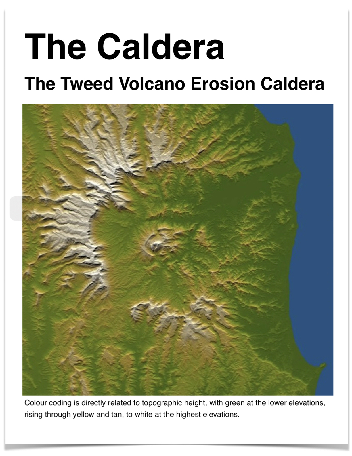
Lava flows from volcanic eruptions over 3 million years left layer upon layer of lava, forming a ‘shield volcano’, a circular, dome shaped mound of layered lava, hardened into hard basalt rock, to a height of 800 meters above the current height of Mt Warning, covering the landscape to the south as far as Alstonville and past Kyogle to the west.
Oxygen and water have ‘chemically decomposed’ the hard basalt rock of the shield volcano into a soft, friable, fine, red colour, fertile clay soil.
Because of the the shape of the coastal landscape, and because of coastal current and weather patterns, and because of the the height and shape of the volcano, there is an unusually high localised rainfall over the volcano.
The the volcano basin shape has been hollowed out by the extreme rainfall over the peak, and streams, creeks and the river have carried away the surrounding soft red basalt soil, exposing lower and lower hard basalt rock layers to the chemical weathering process, eventually hollowing out the ‘erosional caldera’ landform of the volcano.
The East and south-east of the caldera outer wall has been washed away by the ocean, which 125,000 years ago rose to 10 meters higher than today, shallow inland tidal waters flooded the eastern part of the caldera, explaining the extensive flatlands around Murwillumbah.
———-
The entire eastern side of the Australian continent was once rainforest. As the continent moved up the globe the landscape of the whole of Australia became drier. Most of the east continent rainforest dried, and died. Eucylipts, evolving from the rainforest maraquia species, adapting to the drier weather, became the new Australian indigenous species.
———-
Within the Tweed volcano caldera the rainforest also dried and much of the caldera rainforest too was evolutionarily superseded by eucylipt forest, “majestic stands of … quote by whatshisname, the first recorded European account of the forests here”.
However, because of the caldera landform and the high rainfall it induces, and because of the soft basalt soils, remnants of the original east Australia rainforest species ecology had survived in the wet valleys, gullies and creek-sides of the caldera and the volcano’s outer slopes.
The Tweed erosion volcano caldera and its subsequent high local rainfall wet weather pattern has provided a refuge for the original eastern rainforest ecology, which at one time occupied the whole of the eastern part of the continent.
“Rainforest pockets had persisted in the wet refugia of the Tweed Caldera valleys.”
The varied species of plants, fungi, insects, birds, marsupials, … all of the inter-related, interdependent lifeforms of the original east Australia rainforest ecology, had sustained here in the volcano , was self-sustaining, regenerating itself again and again as it had over 20 million years.
-xxxxxxxxxxxxxxxxxxxx-
It was all in existence until very, very recently.
Recently the landscape was cleared. …
In the caldera today the mostly invasive species plants we live with include here and there tree species of the last of the original authentic east Australian rainforest.
In today’s world the rainforest trees are unusual, and if driving in the caldera are noticed by their stems, if its not a camphor or a gum its probably a 20 million year old rainforest species.
Invasive species mostly now populate the landscape, interspersed with tree species of the original authentic rainforest.
—————–
How to help what little is left of the rainforest ecology of the caldera? Heres how: Value the caldera ecology, what little is left of it.
PS. The rainforest species trees are gorgeous, the ecology they support is equally gorgeous too.
——————
NASA: “The [following] image can be seen in 3 dimensions (3-D) by viewing the following left image with the right eye and the right image with the left eye (cross-eyed viewing).
When stereoscopically merged, the result is a vertically exaggerated view of Earth’s surface in its full three dimensions.

