On the 18th of April 2014, members of the Caldera Environment Centre attended a location at Boormans Rd Limpinwood, identified as Lot 127, DP 755724, to investigate allegations of unauthorised earthworks and land clearing.
The impetus for this investigation was a significant flood event that resulted in a massive industrial debris and sediment load entering into the pristine Hopping Dicks Creek and a well-known frog and platypus habitat.
The sediment plume of red soil was observed as far downstream as the Oxley River Bridge, approximately 15km from the Limpinwood site.
The development site is part of a newly subdivided property which has just recently been put on the market, known as Bryant Estate.
————————————————————————————————————————-
The Caldera Environment Centre submits the following as evidence of:
- The origin of the sediment load and waste deposited into Hopping Dicks Creek;
- The magnitude of the sediment load and waste deposited into Hopping Dicks Creek;
- The cause of the sediment load and waste entering Hopping Dicks Creek;
- The lack of concern from regulatory bodies about an imminent, but avoidable ecological disaster;
- That development planning regulatory controls are either ineffective or unenforced;
- The property developers with their eyes on the Tweed’s stunning natural landscapes are acutely aware of point number 5.
————————————————————————————————————————-
September 2013: Significant clearing of the riparian zone along Hopping Dicks Creek and platypus habitat begins. Prior to this, the forest had been thick to the water’s edge. The tractor in the photo below is bogged in the water course.


The event was reported to the Environmental Protection Agency on the 11th September 2013.
The event was reported to the Tweed Shire Council on the 16th September 2013.
The event was reported to the NSW Office of Water on the 16th September 2013.
The report to the NSW Office of Water was subsequently followed-up, but it was discovered they had inexplicably closed the case. A new case was opened on the 20th March 2014.
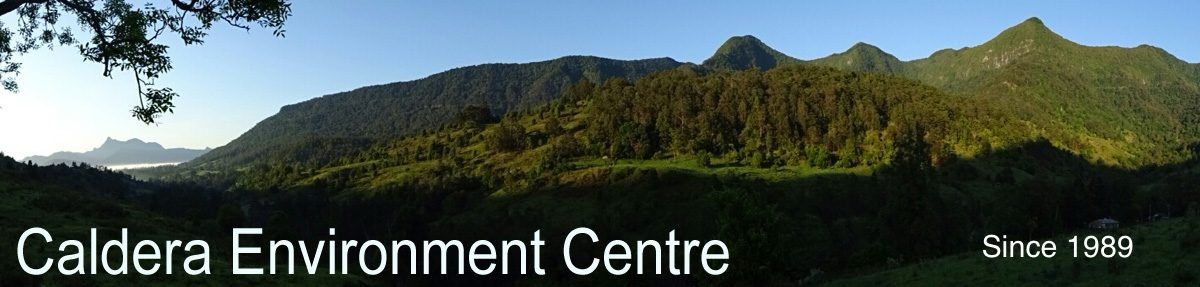
To add insult to injury, a water tanker was observed blocking access to the neighbouring property and extracting water from the creek. This causeway was severely damaged by heavy machinery, large trucks and earthmoving equipment, depositing concrete debris into the creek.

Water extraction from the platypus habitat was taking place 5 days a week.

February 2014: Following 5 months of industrial noise and activity, after being seen daily, the platypus had not been seen for 2 months.
- Tweed Shire Council Platypus Project
- Tweed Shire Council launches Tweed Platypus Project
- Help sought to protect Tweed platypus habitats
March 2014: A rain event on the 9th flushes the bare red soil into Hopping Dicks Creek where the riparian zone had been cleared.


At this stage, the NSW Office of Water and the Tweed Shire Council appear confused over jurisdiction.
Excavation and bulk earthworks are in full-swing on the property near the end of March.
Mining size dump trucks are observed moving boulders.

An enormous scar on the landscape is observed from the Tyalgum lookout/refuse site.

At the bottom of the scar lies the pristine Hopping Dicks Creek.

On the 28th of March 2014, a major rain event occurred, dumping over 300mm of rain…


A picture taken looking up the road which has been bulk-filled with demolition rubble shows the origin and the path of the mass sediment load and construction waste that pollutes Hopping Dick Creek.

Deposits of sediment from the road works and development site above is shown in the location below.

60cm of red mud is deposited onto the neighbouring property.

April 2014: Excavation work has continued for 7 months unabated, despite regulatory bodies having been alerted in September 2013.
————————————————————————————————————————-
The EchoNet Daily picks up the story:
Tweed Waterway Pollution Blamed on Earthworks
- Heavy rains that washed tonnes of soil into a nearby waterway … described as an ecological disaster.
- Tweed Shire Council recently fined owner $1500 for unauthorised earthworks on the property.
- Tonnes of red silt that drained into Hopping Dicks Creek … wiped out vital habitat for platypus and frogs.
- Broken concrete, tiles, fibro, plastic, electric cables and other waste products … also going into the creek as well as the mud.
http://www.echo.net.au/2014/04/tweed-waterway-pollution-blamed-earthworks/
————————————————————————————————————————-
MEMBERS OF THE CALDERA ENVIRONMENT CENTRE ATTEND THE SITE ON THE 18TH OF APRIL 2014.
The view from the entrance gate looking up the hill towards cleared road and housepad (top left of picture). The silt traps were installed AFTER the major rain event, on Council orders and in recognition of the sediment load and the path of travel.
Mass amounts of sediment-laden water flowed from this area (and beyond) of the site. The location of the sediment traps shows where the bulk of the water entered the nearby gully that leads into Hopping Dicks Creek. The gully is to the far right of this shot (out of frame).

The quantity of the boulders in this location indicates the level of bulk earthworks that has taken place to this point, The padlocked gate has been installed across a crown road.

Silt traps installed after the rain event — the level of siltation beyond the traps illustrates the amount of sediment flow during that event (see photos below).

This is the area beyond the silt traps. Beyond the tree line is a gully which had up to 60cm of sediment deposited. The gully leads through the neighbouring property and into Hopping Dicks Creek. This was a significant frog habitat. Frog calls have not been heard since the major rain event.


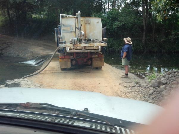
This is about 20 metres down the road from the picture above (heading towards the causeway and creek). Shown in this photo is the construction waste rubble that was deposited to enable trucks and heavy machinery to enter the property.

The demolition rubble fill.


The construction rubble, including plastic and electrical waste which entered the creek along with the tonnes of red soil sediment.
Photo taken from the causeway, facing up the road. The red line shows the estimated ground level PRIOR to the earthworks and fill. This was done to mitigate against the bogging of heavy vehicles entering the property. The exposed red soil is evidence of major water flow heading downhill towards the causeway and creek.

End of the road, causeway and Hopping Dicks Creek. Evidence of major water flow is observed on the right.

Previously a 1 metre deep creek and frog habitat on the neighbouring property. 60 cm of sediment entered the creek from the gully beyond the sediment traps beside the cleared road.

Further along the sediment choked creek which drains into Hopping Dicks Creek.


End of creek, point at which it entered drainage pipes under the neighbouring property’s driveway access. The level of sediment is indicated by the amount filling the drain on the left. From this location, members of the CEC observed a distinct sediment trail leading back to the gully running beside the pile of boulders beside the cleared road.

Sediment flow across neighbouring properly exiting from the gully creek and entering Hopping Dicks Creek.

One point of entry of sediment flow into Hopping Dicks Creek. This ‘beach’ was formerly exposed basalt stones.

Another sediment entry point into Hopping Dicks Creek at the end of the sediment path beginning from the gully beyond the road sediment traps.


Aerial photograph showing magnitude of the clearing on the development site, cause and origin of the mass sediment input into the gully creeks below which lead into Hopping Dicks Creek. Previously identified housepad and road gate site are in the centre-left of the photo.

Sediment-laden river at the Oxley River Bridge, approximately 15km from development site.

————————————————————————————————————————-
June 2014:
The Tweed Daily News picks up the story:
Developer Ordered to Stop Works
- Tweed Shire Council liaising with owner since September regarding unauthorised work at the site.
- Council to defer its consideration of further legal and enforcement actions until outcomes of a NSW Crown Lands Investigation.
- The owners have been requested by Council to stop work at he site.
- The developer has been forced to put temporary sediment control measures in place to prevent further damage, in line with a Council Clean Up Notice.
http://www.tweeddailynews.com.au/news/developer-ordered-stop-works-limpinwood/2291980/
————————————————————————————————————————-
July 2014:
The Developer responds:
- Denies earthworks at property have caused environmental damage.
- Was vague about current approvals for an internal road he allegedly built on his property.
- Claims neighbours and the Caldera Environment Centre are “lying” about damage from the run-off.
- Said the Tweed region presented an “untapped resource”.
- Plans to continue to look to the Tweed for “some very big ventures”, including a $45 million cable car operation at Mt Warning, hoping to attract 3000 people a day.
http://www.tweeddailynews.com.au/news/developer-fights-back/2302332/
————————————————————————————————————————-
‘ Bryant Estate ’
Another subdivision and development of the sensitive Tweed Caldera Bioregion…
[ http://www.psmithandson.com.au/10288373 ]Lots 127, 128, 129, 113
Boormans Rd, Limpinwood
————————————————————————————————————————-
UPDATE
On 17 June 2014 the NSW Trade and Investment Crown Lands Division (CLD) provided the following update in terms of their current investigation on compliance issues affecting the Crown Reserve on the subject site to Tweed Shire Council.
The NSW Soil Conservation Service (SCS) provided a report to Crown Lands and to the site owner outlining required remediation works in regard to the affected Crown road reserve, and to the adjoining private property.
The owner has verbally agreed to undertake the works required, and this will be followed up with a formal agreement with Crown Lands, and has indicated work will commence as soon as possible.
The SCS will inspect and provide Crown Lands with a report following completion of the works to SCS’s satisfaction; and
The owner has lodged an application to close and purchase the subject section of Crown road reserve, and Council will be notified in due course of this action.
Tweed Shire Council is discussing the matter with their solicitors and awaiting the outcome of the Crown Lands investigation.
—————————————————————————————————————————
